11 November - 17 November
Section outline
-
Enter text here...

FOCUS / ARONGA learning intentions:
- We are FOCUSING on developing our map reading skills so we can think like a geographer
- We are FOCUSING...
- We are FOCUSING...
Enter text here...

Map and Globe Skills Review
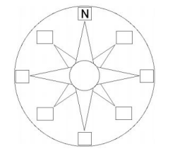
Cardinal and Intermediate Directions
Terms you will need to know: compass rose, cardinal directions, intermediate directions. Skill you will need to have: how to determine cardinal and intermediate directions from and to a given location.
Label the blank compass rose with S, E, W (these are called cardinal directions, along with N), then add NW, SW, NE, SE (these are called intermediate directions).
Map Data
Terms you will need to know: map data, points, lines and areas.
Map data consists of POINTS, LINES and AREAS. On the map below, the location of Stillwater Junior High School is indicated with a POINT (in the shape of a star).
1. Provide an example of a location on the map below that is indicated with a LINE:
2. Provide an example of a location on the map below that is indicated with an AREA:
1
Parts of a Map
Terms you will need to know: TODALSS. Skills you will need to have: how to read a map legend and map scale, how to include accurate TODALSS elements on maps that you create.
Go to: http://tinyurl.com/8yr9v2c
Use the article to answer the questions below:
1. A “good” map includes seven TODALSS elements. What do T, O, L and S stand for?
T =
O =
D = Date (date that the map was made)
A = Author (name of the map’s cartographer)
L=
S=
S = Source (where the data that the map is based on is from)
Click on the link to scale in the article.
2. What does the scale of a map indicate?
3. Which kind of map shows more detail, smallscale or largescale?
2
Continents and Oceans (Use an atlas if needed)
Terms you will need to know: continent, ocean, hemisphere. Locations you will need to know: Africa, Antarctica, Asia, Australia, Europe, North America, South America, Arctic Ocean, Atlantic Ocean, Indian Ocean, Pacific Ocean, Southern Ocean, Northern, Southern, Western and Eastern hemispheres.
Label the 7 continents and 5 oceans on the map below. Draw a SOLID LINE to separate the Northern and Southern hemispheres. Draw a DOTTED LINE to separate the Western and Eastern hemispheres.
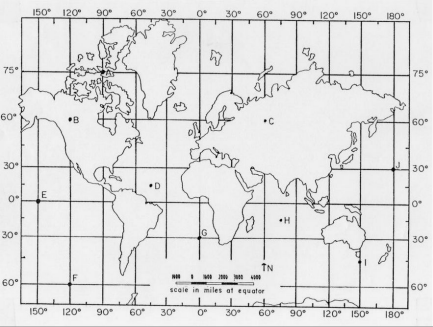
3 Latitude and Longitude
Terms you will need to know: hemisphere, Equator, parallels, meridians, Prime Meridian, International Date Line, latitude, longitude. Skill you will need to have: how to determine absolute location using latitude and longitude coordinates.
Go to: http://tinyurl.com/yjx43kz
Scroll down the page until you see the black box below. Use the tutorial to help you answer the questions below. You’ll need to click the green arrow in the lower right hand corner (requires FLASH).
1. A hemisphere is:
2. The Equator is:
3. Meridians are:
4. The Prime Meridian is:
5. A line of latitude (also called a parallel) is:
6. A line of longitude (also called a meridian) is:
7. How many total degrees of longitude are there?
8. How many degrees of latitude are there between the Equator and the North Pole?
The Equator and the South Pole?
Prime Meridian
Go to: http://tinyurl.com/39nanx
4 Use the article to help you answer the questions below.
1. What is the International Date Line?
2. When and how was the Greenwich Meridian selected as the official Prime Meridian?
3. Identify the latitude and longitude of each location on the map:
Location
Latitude (N or S)
Longitude (E or W)
A
B
C
D
E
F
G
5 Map Projections
Term you will need to know: map projection. Understanding you will need to have: why geographers use different map projections rather than one map projection.
View this video, “Map Projections”, to gain a better perspective on what map projections are: http://tinyurl.com/odgcoog
1. What is a map projection?
2. Why do you think geographers use different map projections rather than just one?
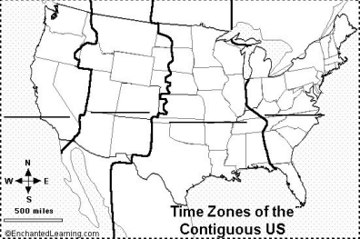
Time Zones
Terms you will need to know: time zones, contiguous. Understanding you will need to have: why we use time zones instead of uniform times around the world. Skills you will need to have: how to read a time zone map and calculate time differences between locations.
.
Go to: http://tinyurl.com/de2ezc
Under “Toys” on the left side of the window, click on world sunlight. Underneath the earth image, click on the various map projections to explore how they change the image (Mercator, Peters, Mollweide, equirectangular, etc.)
1. How does the World Sunlight Map help us understand the need for time zones?
Go to: http://tinyurl.com/7bt8mod
Use the article to help you answer the questions below.
1. How did the development of the railroad spur the adoption of time zones?
2. Time zone facts:
a. Total # of world time zones:
b. Distance apart:
c. When world time zones were officially established and where:
d. # of time zones in China and # of time zones China would have if it conformed:
e. Meaning of acronym UTC:
f. # of time zones in contiguous U.S.:
g. # of time zones in U.S., including AK, HI and overseas territories:
6
Go to: http://www.freelargeimages.com/wpcontent/uploads/2014/11/Time_zone_map9.gif Use the World Time Zone map to help you answer the questions below:
1. If it is noon in Dallas, TX, USA, what time is it in Lisbon, Portugal?
2. If it is noon in Manila, Philippines, what time is it in Casablanca, Morocco?
3. If it is noon in Oslo, Norway, what time is it in Karachi, Pakistan?
4. If it is noon in Singapore, what time is it in Santiago, Chile?
Label the contiguous U.S. time zones with their names (write on the dark lines on the map).
7