5 June - 11 June
Section outline
-
GEOGRAPHY – SKILLS BOOKLET
Contents Page
PAGE
TOPIC
TICK WHEN
COMPLETED
1 - 13
SECTION 1 – MAP SKILLS
23
Notes page
How to use your skills booklet
Attempt EVERY question as answers will be self and peer reviewed during lessons
Coloured boxes indicate question levels. Tick the colour matching the level of question you have answered
Purple boxes indicate areas where you can “level up” your skills and explains how to do so, with practice questions
SELF/PEER ASSESSMENT
WWW
EBI (Areas I am still unsure about)
e.g. I am able to identify 4 figure references …
e.g. You are able to compare maps and identify human features
e.g. I am unsure how to complete 6 figure references
e.g. You need to review how to read population graphs
RED PEN REFLECTION
TEACHER COMMENT
Use the green self-assessment boxes to complete the in class self/peer assessment activities
Glossary of key words and command words
KEY WORDS
OS Map
Ordinance Survey Map
grid reference
a map reference indicating a location
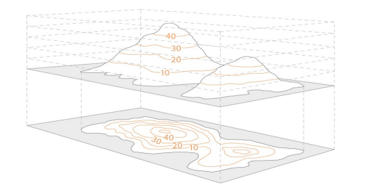
Contour lines
a line on a map joining points of equal height above or below sea level (demonstrating height)
Fossil fuels
Natural fuel formed from the remains of living organisms. E.g. Oil and Gas. Fossil fuels are NON RENEWABLE.
Non renewable
Finite. It will eventually run out
Renewable
Energy sources that are replenished and do not run out, e.g. Solar Power
population
all the inhabitants of a particular place.
weather
The day to day changes in atmosphere
climate
the weather conditions of an area over a long period of time
atmosphere
thin layer of gases that surrounds the Earth.
Command Word
Meaning
account for
explain (reason)
analyse
examine closely; examine in parts; show how the parts contribute to the whole
assess
decide the value of; judge; measure the importance of
compare
discuss two or more things in terms of their similarities and differences
critically evaluate
weigh arguments for and against something; assess all evidence; decide which opinions, theories, models or items are preferable.
describe
give a detailed account of the features of something without interpreting the
information
discuss
present and give a judgement on the value of arguments for and against; consider all angles
evaluate
judge; criticise in terms of
impact/significance, and investigate the implications
examine
make clear the details/meaning of; look in particular at reasons, causes and effects; account for; give reasons; justify
explore
describe in detail and note impact
indicate
focus on specific areas (similar to illustrate)
interpret
make clear the meaning of; consider
implications
outline
describe main features; give a broad but thorough account; identify briefly the main features of
relate
show similarities and connections between two or more things
review
describe chief features and criticise generally (important parts)
GEOGRAPHY – SKILLS BOOKLET
SECTION 1 - Map Skills
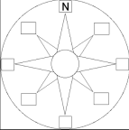
1. Label the 8 points on the compass
NW
NE SE
2. Label the following continents and oceans
1. Antarctica 2. South America 3. North America 4. Africa
5. Australasia 6. Europe
7. Asia
8. Southern Ocean 9. South Pacific 10. North Pacific 11. Indian Ocean 12. Arctic Ocean 13. North Atlantic 14. South Atlantic
GEOGRAPHY – SKILLS BOOKLET
3. Complete the grid references section of the booklet
14
13
12
11
HELPFUL HINTS:
Remember, coordinates can be separated into 4 and 6 figure references.
i.e. 54 67 OR 56 8 57 4
How to:
To find a location on the map, follow the grid along to the row your location is in. This is your “Easting”.
Then, move up the column (your “Northing”) to the box your location is in.
You can remember this as going “along the corridor and up the stairs”
GEOGRAPHY – SKILLS BOOKLET
4. OS Maps and symbols
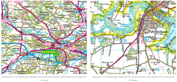
What is a map scale?
The scale of a map shows how much you would have to enlarge your map to get the actual size of the piece of land you are looking at. For example, your map has a scale of 1:25 000, which means that every 1cm on the map represents 25 000 of those same units of measurement on the ground (for example, 25 000cm = 250 metres).
That might sound a bit complicated, but OS maps have been designed to make
understanding scale easy. Look at the front of a 1:25 000 scale map and you will see that the scale has been also written out for you like this:
4cm to 1km
This means that every 4cm on a map = 1km in real life. To make it even easier, the grid lines are exactly 4cm apart, so every square is 1km by 1km.
Describe the differences between the two different scales of map
Explain why it is useful to have maps in different scales
Page | 5
GEOGRAPHY – SKILLS BOOKLET
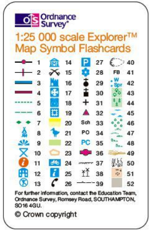
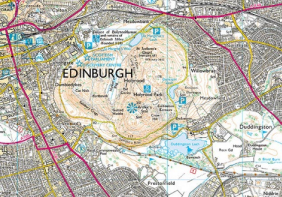
OS symbols
Name the OS symbols
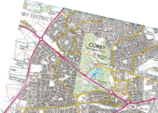
FIGURE A. State the types of tourism available in Figure A
Describe the human landscape of Figure A
Explain the human landscape of Figure A, in reference to tourism
Page | 8
GEOGRAPHY – SKILLS BOOKLET
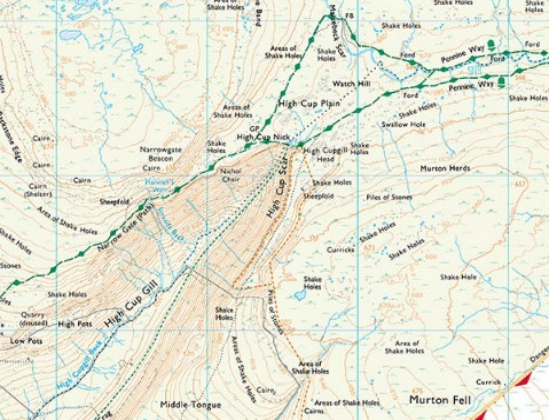
TASK:
Using the contour map and hint box above, draw a sketch map of the landscape looking West from Meadow field
Describe the change in landscape from the top of the Pennie Way (NE) to the end of Narrow Gate (Path) (SW)
FIGURE 1
Human landscape –
Landscape designed and adapted by humans. For example roads, buildings, cultivated farmland
Physical landscape –
The natural landscape, for example woodlands, forests, rivers and hills/mountains