23 October - 29 October
Section outline
-

FOCUS / ARONGA learning intentions:
- We are FOCUSING on our current knowledge and skills to understand how this can change our levels of achievement.
We are revising our mapping skills and knowledge to understand the different types of maps and how they are used world wide.
How can maps tell stories?
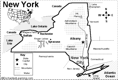
Directions: Look at the map below. Answer the questions that follow.
1. Which state is the subject of this map?
2. What is the capital of this state.
3. The capital is close to a river. What is the name of the river?
4. Why do people build cities near rivers?
5. Is New York City in the north or south of the state?
6. Based on the map and what you know about life in New York, do you think this state is more influenced by its mountains or access to rivers and lakes? Explain.
How can a map show where people live?
Directions: Look at the map below. Answer the questions that follow.
1. Which state has the most Hispanics (Latinos)?
2. Which state has more Hispanics, New York or Texas? Why does it have more, in your opinion?
3. Which of those states do you know the most about and why?
4. Why do you think most Hispanics in the United States chose those five states? What is there for them that is not in other places?
5. If you had to move to another state, which one would it be and why?
6. How is this map showing the population, and how can this information be useful for you?
How does a grid system work?
Directions: Look at the map below. Answer the questions that follow.
1. Write the name of each place in each location. Use the line to write the name.
C6
I4
B3
G3
J1
J7
E3
A7
2. If you were at the Fire station, which direction would you take to go to the community center?
3. How are maps on smartphones different from paper maps?
4. Add a cartoon character at AE. What is directly north of AE and leads to City Park?
5. Why is this map limited in what it can do, in your opinion?
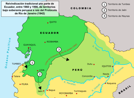
Are the Borders of a Country Unchangeable?
Directions: Look at the map below. Answer the questions that follow.
1. This map is in Spanish, and it shows a territorial dispute between which two Spanish-speaking nations?
2. What is the name of the treaty that was signed in 1942 that allowed Peru to take half of Ecuador?
3. How do you think the loss of access to so many rivers affected the economy and life in Ecuador?
4. How do you think Ecuador would be different if it still controlled all the land that was taken?
What are the Essential Features of Political and Physical Maps? Directions: Complete the exercises below to review what you learned in class. Write in complete sentences.
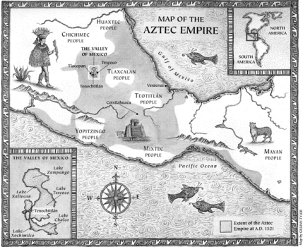
Types of Maps
1. What is the title of this political map?
2. Write the name of one small group of people whom the Aztecs did not conquer.
3. The Aztec empire existed on which continent?
4. Is this a physical map, a political map, or both? Explain your answer.
5. In which direction from the Valley of Mexico did the Aztecs expand the most? Use the compass.
6. In which direction on land did they expand the least? Why do you think they did not go far in that direction?
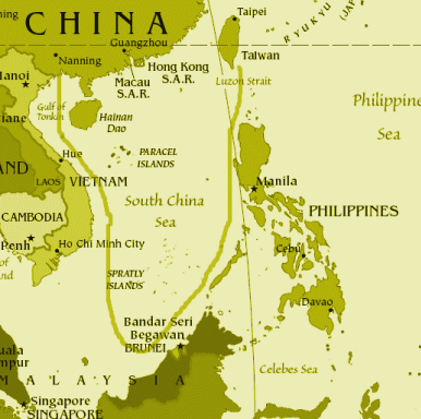
Using a Political Map – Real World Application #1
China is claiming a lot of ocean territory in the South China Sea. You can see the big line that extends far south from China. Look at the map above and answer the questions that follow.
1. Write the names of three countries that you think may be angry about the claims of China.
2. China says it has the right to that territory because a thousand years ago a Chinese sailor controlled one of the islands for a few years. Do you think it is fair or not that China wants all that ocean territory? Explain your answer.
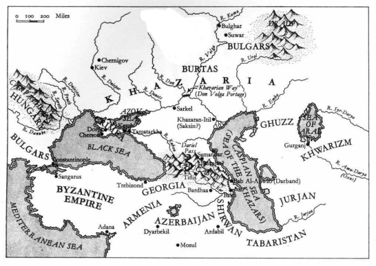
Using a Physical Map
1. The Byzantine Empire is protected by which two bodies of water?
2. If the Bulgars people wanted to invade Georgia, what two obstacles will be in their way? 3. Which city has more access to trade routes and why: Kiev or Mosul?
4. The Mongols traveled across Khazaria on their way to Europe. They were stopped when they reached Hungary. Why?
5. Which nation of people do you think was least protected from invasions and why?
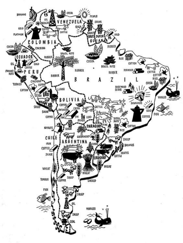
What are the Essential Features of Thematic Maps?
Directions: Complete the exercises below to review what you learned in class. Write in complete sentences.
1. What type of information
does this map show?
2. Write the names of three products you can find in Brazil.
3. Write the name of one
country that has no gold.
4. If you wanted to make a farm to grow coffee, how is this map useful for you in deciding where to start your
business?
5. Which country has the most diverse resources within its borders?
6. Which country has the least resources in its borders?
7. Based on this map, which country should be the most powerful in South America and why?
Cultural Distribution Map
1. Write the names of three cultures that existed in ancient Mexico.
2. Write the names of three cultures that constructed pyramids.
3. Which region in northern Mexico has no people. Why do you think there are no people there?
4. Write the names of three cities built by the Mayans.
5. Thinking about what you need for a large population, what can you guess about agriculture in Mexico and the large number of cultures that existed there?
Global Studies Map Assessment Sample Questions
Part 1: Basic Map Vocabulary
Directions: Use the vocabulary words to complete the sentences below. Some words will be used more than once.
Words to Use
Thematic Physical Political Map Key Symbol
1. A __________________ map shows the names and borders of countries. 2. If you want to understand how to use a map, then look at the _____________________.
3. __________________________ maps show elevation of the land using colors.
4. A __________________________ map can show information such as population and resources.
5. We use a _________________ in place of a picture to show things on maps.
6. I want to make a plan to go on vacation so I will use a _________________ to plan my driving and a _________________________ map to plan where I want to hike, camp and swim.
7. If I want to compare the resources of different countries then I should use a ______________ map.
- We are FOCUSING on our current knowledge and skills to understand how this can change our levels of achievement.